


Horse caravans and post stations on the Tea Horse Road, from the Complete Map of Jinsha River, the 7th year of Qianlong (1742) in the Qing Dynasty, supervised by Yunsui Zhang, the Governor-General of Yunnan. Photographed at The First Historical Archives of China, Beijing, China
The innovation
STORIES proposes a resilience thinking (instead of risk thinking) in flood studies and investigates the social resilience to flood hazards with a historical perspective. It leads innovations in three aspects:
- Detecting the internal drivers and mechanisms of flood resilience in networked social systems
- Developing a new modeling tool of combined ABM and SNA for resilience studies
- Generating alternative resilience strategies to inform flood management
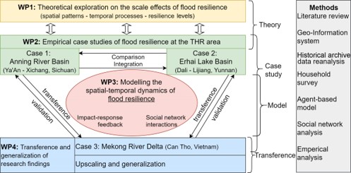
Research framework
The project is composed of four work packages (WPs) as structured in the graph.
- WP1: Theoretical exploration on the scale effects of flood resilience
- WP2: Empirical case studies of flood resilience in the THR region
- WP3: Modelling the spatial-temporal dynamics of flood resilience in the THR region
- WP4: Transference and generalization of the research findings
Study areas and data
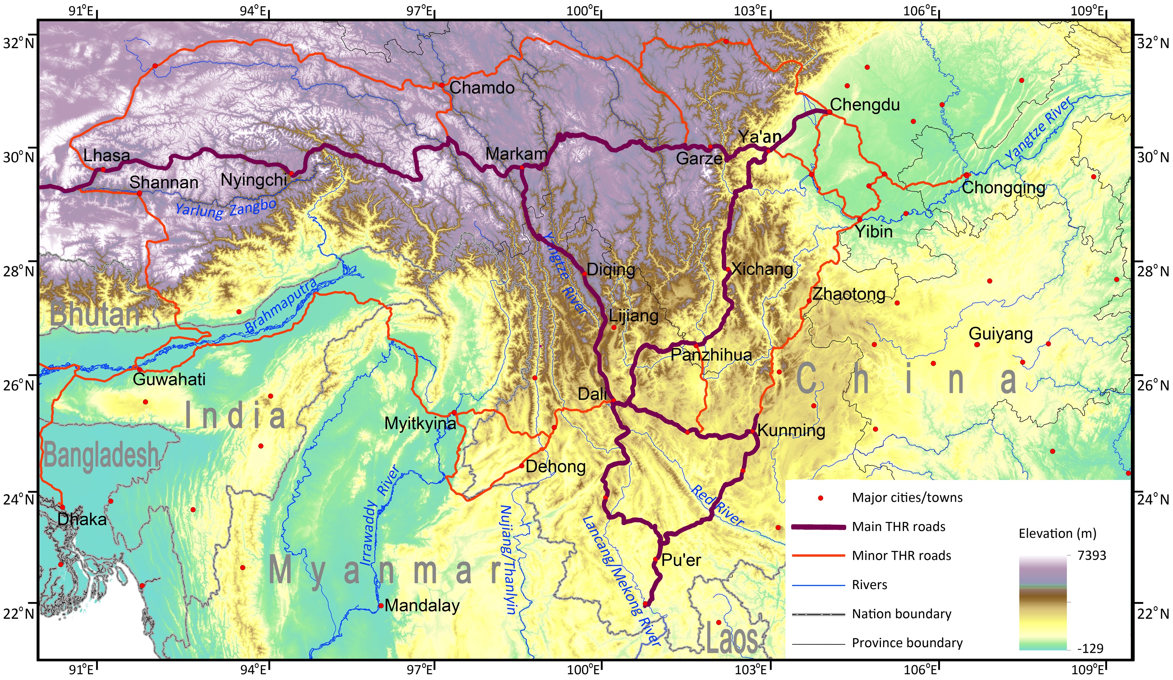
The historical Tea-Horse Road (THR; 茶马古道 in Chinese), sometimes referred to as the Southern Silk Road, was a network of caravan paths winding through the mountains of Sichuan, Yunnan and Tibet in Southwest China and further toward South Asia. It partially originated in the early Qin dynasty (221-207 BCE) and thrived in the Tang dynasty (618-907 BCE) and Song dynasty (960-1279 BCE) through to the Republic of China (the mainland period of 1911-1949). During the over two millennium period, trades were spontaneously formed and developed by local people to exchange tea, horses, silk, salt, furs, medicinal herbs, and so on among inland China, Tibet, and ancient India. Goods were mainly carried by people and horses. There are many surviving archaeological and monumental elements along the roads, including trails, bridges, way stations, market towns, palaces, staging posts, shrines, and temples. Beyond its commercial importance, the THR was a vital link between the various ethnic groups of in southwest China, Tibet, and the Indian subcontinent for economic and cultural exchange. Although globally less known than the Silk Road, the THR is of similar significance regarding its historical, geographical, and cultural implications.
The large THR area typically covers low plain lands in the Sichuan Basin, the middle mountains in Yunan, and the high mountains in Tibet. Among the road network, two major roads connected Tibet with Sichuan in the north and Yunnan in the south. They cross four large rivers, including the Yangtze (Jinsha), Lancang (Mekong), Nujiang (Salween), and Yarlung Zangbo (Brahmaputra). In recent decades especially since China’s “Belt and Road Initiative” in 2013, the new transportation construction has largely improved transportation efficiency, significantly promoting intra-regional socio-economic development and inter-regional connections.
The THR region is unique for studying flood resilience, given that:
- It represents typical mountain areas where human societies develop in valley flatlands and suffer from multiple water-triggered disasters, e.g., floods, debris flow, and landslides. The local people have rich experiences living in and cope with these hazard prone environments.
- Many ethnic minorities live in the region and have developed a prosperous economy and trade along the THR. It offers resilience cases of marginalized and underrepresented communities to harsh flood-prone environment both in the past and at present.
- Flood impacts were significantly reduced over time due to the implementation of multiple and diverse flood management measures at various levels. Economic development and population growth in the region are not seen as exposure factors but as resilience measures in managing floods and other hazards.
- Rich historical archives, documents, maps, and local chronicles are available in the long historical period, providing valuable materials for examining resilience changes over space and time.
The Vietnamese Mekong River Delta (MRD) is also selected for studying flood resilience and comparing with THR region, given its different features of flood resilience in different natural and social systems:
- MRD represents a flood environment of combined riverine flood and tidal flood in an extensive flat region. Floods were never mitigated but well adapted.
- MRD is highly dependent on rice planting and aquaculture. While, THR has mainly dry farming, livestock feeding and economic forestry. The different livelihood strategies are likely to be reflected in their flood management and response activities.
- MRD has a dense network of natural and man-made channels. The operation of many dykes, sluice gates, and pumping stations largely managed the floods and enabled the living of about 18 million people in the MRD. This differs from the THR region where river channels are mostly nature.
- THR has small towns with loosely distributed villages in mountain valleys, while MRD has bigger cities with denser population in general.
- Though largely different, the THR and MRD are also naturally linked by the Lancang-Mekong River, where they often cooperate on water management issues under the Mekong River Commission. This further allows potential opportunities to examine flood resilience at the river basin scale.
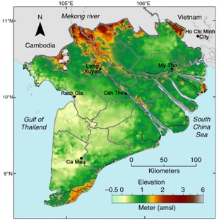
Re-edited based on (Minderhoud, et al 2019)
Methodology
The complexity of flood resilience calls for the application and integration of various methods. The project will develop a common methodological framework, including a literature review with a data reanalysis, a geographical information system (GIS), a field investigation, participatory household surveys, an agent-based model (ABM) and social network analysis (SNA). Further, empirical approaches will help examine the study's relevance and differences with those in other regions.
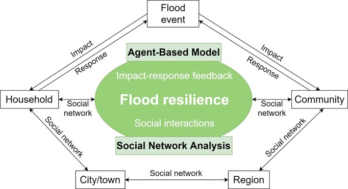
Specifically, STORIES uses ABM to simulate individual households’ resilience that interacts within the social networks over different temporal processes. It is proposed with the ABM to investigate floods’ impacts, household responses, and community mutual relief networks in the selected study area, and SNA to identify the interactions and relationships among different actors concerning managing flood impacts. The aim is to reveal the effectiveness and efficiency of social connections in improving flood resilience. Information about the flood impacts and responses, social connections and relationships will be obtained from the household survey data and various archive documents.
The integration of the ABM and SNA enables simulating the system dynamics and reflecting the internal interactions of flood resilience in networked social systems.
Data sources
The project collects historical data to detect the flood impacts and social responses in the past 600 years in the case areas. Flood resilience analysis in recent and present time are supported with field observation data, large-scale household interview data, available monitoring data, statistical data, and research overviews.
Historical data will be collected from various geo-archaeological proxies, historical archives, gazetteers, local chronicles, compiled datasets, literature re-analysis and recent research results, which provide information on meteorological and hydrological records, flood events, disaster impacts, disaster relief and recovery with focusing on floods. The project team has the necessary accessibility to and the language advantage to read various ancient Chinese documents. A few major archive materials have already been collected in preliminary studies in the area.
Large scale household surveys will be carried out to collect data about recent flood situations in the case areas with the cooperative support by local partners. The target respondents are household heads who know about specific flood disasters and impacts. A questionnaire is designed to cover questions of family’s basic conditions, flood preventions, specific responding strategies, self and mutual relief activities, knowledge on flood risks, available network resources, perspectives on flood trends, final flood losses, and ideas and expectations on resilience-building, etc.. First household survey is planned to be taken in summer 2023.